Research objectives and methodology

The research methodology is based on a multi-disciplinary approach that links together several tools designed pixel wise as: numerical soil moisture energy – water balance models, crop model, assimilation of satellite data, estimation in real time of present and future soil water content with daily to seasonal forecast horizons.


The project aims to improve farm and irrigation district water use efficiency and farm profitability developing a real-time operational irrigation management web-gis system for parsimonious and precise irrigation optimizing exact water use and relative water productivity, integrating farm analysis into irrigation district ones.


The SMARTIES system will be designed to be used: i) in real time mode during the irrigation season to support irrigation strategy for weekly and seasonal forecast; ii) in an off-line mode, before the irrigation season, as a simulator of irrigation and crop yield strategy under seasonal forecast conditions supporting crop and irrigation decision strategy and the irrigation water policies impacts.


In addition to the above operative objective, several scientific objectives will be addressed.

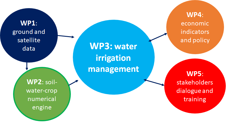
The objectives stated above will be achieved through a number of interconnected and synergic activities, which are divided in work packages (WP), with their own deliverables.

WP0 - Coordination

WP Leader

POLIMI

WP Participants

UNITUS, UVEG, LIST, UCD

Starting Month

1

End Month

36

Task

Task.0.1: Meetings, internal communication and reports.

Task.0.2: Risk management

Deliverables

D.0.1: First project report
D0.2: Final project report
D0.3: Meetings minutes between project partners on risk management

WP1 - Ground and satellite data

WP1 will collect and analyse ground and satellite data relative to each of the five cases studies providing a homogeneous dataset of soil moisture and evapotranspiration, irrigation practice, crop type, meteorological forcing.

Two different temporal databases will be built: i) in an operational phase for the real time SMARTIES functioning and ii) in reanalysis for verifying models accuracy.

WP Leader

UVEG

WP Participants

POLIMI, CNRISAFOM, ASWAN, CESBIO, LIST, UCD, ESIM, INRGREF, ISA

Starting Month

1

End Month

35

Task

Task.1.1: ground monitoring

Task 1.2: remote sensing data

Deliverables

D.1.1: Consistent data base of meteorological, hydrological, radiometric data, crop biomass and yield data for each case studies for a reanalysis period and real-time data

D.1.2: Consistent time series for a reanalysis period and real time for each study area: i) albedo; ii) LST, iii) LAI and fractional cover, iv) water stress index, v) SM

D1.3: data management plan for Horizon2020 Pilot on Open Research Data

WP2 - soil-water-crop numerical engine

WP2 will provide the numerical modelling tools required in SMARTIES for managing irrigation water. Different numerical models will be used in different local case studies. An effort to standardize the model outputs will be made in order to have the possibility to compute the same water management indicators. All the models will be run for same reanalysis periods for their calibration/validation activities and afterwards, all the models will be implemented using real time data, at daily and seasonal scales, during the service implementation and validation.

WP Leader

LIST

WP Participants

POLIMI, CNRISAFOM, MOPI, CESBIO, LIST, UCD, INRGREF

Starting Month

1

End Month

36

Task

Task 2.1 Real-time daily and seasonal meteorological forecast

Task 2.2 Soil water balance modelling inferred by remotely sensing

Task 2.3 Crop growth modelling and stress thresholds

Deliverables

– D2.1: daily and seasonal meteorological forecast maps
– D2.2: evapotranspiration, soil moisture and irrigation water requirements maps from both FEST-WEB and STIC model for the case studies
– D2.3: dataset of stress threshold values for irrigation scheduling
– D2.4: yield estimates from coupled hydrological and crop models

WP3 - Irrigation water management

This WP will allow a smart irrigation water management through the operative web gis tool, based on a unique irrigation strategy for determine the correct timing and amount of irrigation reducing water losses by evapotranspiration or percolation (hence the associated nitrate load) and soil salinization. Irrigation water demand for any cultivated pixel of the basin will be computed as the water needed to maintain soil moisture between the field capacity (percolation thresholds) and the crops stress thresholds

WP Leader

POLIMI

WP Participants

MOPI, ASWAN, UCD, ESIM, INRGREF, ISA

Starting Month

16

End Month

36

Task

Task 3.1: SMARTIES irrigation strategy

Task.3.2 open access web gis dashboard

Task 3.3 simulator

Task 3.4 water indicators

Deliverables

-D3.1: irrigation strategy definition and tests
-D3.2: operative web dashboards for the case studies
-D3.3: simulator tool
– D3.4: water indicators

WP4 - Economic indicators and policy

WP4 will conduct an economic analysis providing homogenized economic indicators at two different spatial levels: farm and district scales. The first will evaluate the benefit provided by the SMARTIES irrigation strategy scaling-up from the field to the farm, the second will evaluate the impact of these approach at the irrigation district level starting from the present conditions of irrigation practices and simulate the improvements associated with the parsimonious use of water in seasonal and monthly water availability. The economic
effects of adopting the SMARTIES strategy will be also assessed simulating different context of water resource management and pricing, and the relative water policies.

WP Leader

UNITUS

WP Participants

ASWAN, CITA

Starting Month

6

End Month

36

Task

Task 4.1: Farm-level analysis

Task 4.2 District-level analysis

Deliverables

D4.1: on-farm economic indicators assessment of the net benefits related to crop production using conventional and parsimonious irrigation for selected crops
D4.2: water user associations and irrigation district economic indicators assessment of the benefits related to crop production using conventional and parsimonious irrigation for selected crops

WP5 - Stakeholders communication and training

The WP main objective is the involvement of stakeholders and the diffusion of project results among a broad range of users. This is based on the implementation, for each case–study, of a system of interactions through participatory sessions to review the analyses of WP3 and provide feedbacks

WP Leader

UCD

WP Participants

POLIMI, UNITUS, CNRISAFOM, MOPI, ASWAN, UVEG, CITA, CESBIO, LIST, ESIM, INRGREF, ISA

Starting Month

1

End Month

36

Task

Task. 5.1: Case studies end-user involvement

Task. 5.2 Dissemination

Deliverables

-D5.1: Case studies end-users’ needs definition
-D5.2 : list of diffusion activities
-D5.3: list of diffusion activities
– D5.4: Exploitation plan for SMARTIES dashboard patent